Most of our history lessons have come from textbooks, our teachers, and professors, and for some people, their education ended there. If, as I do, you have a real interest in the tales of days gone by, then you probably welcome any chance you get to learn something new, be it in a museum, on tour through a historic site, or simply by studying a map.
Maps are more than just guides directing you about how to get from one place to another; they are windows into the world’s past. In my last discussion of maps, I discussed the inaccuracy of archaic maps – primarily their geographic representations and the inclusion of fabulous fictional objects in uncharted territory. Nevertheless, through studying such maps, we can gain otherwise inaccessible insight into how humans’ understanding of geography has evolved.
Today, it’s hard for young people even to imagine a time when satellite imaging didn’t contribute to mapping. Today, you can use Google Maps to take you just about anywhere in the world. You can type an address into Google Earth and pull up an interactive street view of the surrounding area – the next best thing to walking down the street yourself. Mapping has come a long way since the introduction of satellite imaging, but before maps made the major shift from print to digital, there were many other discoveries that shaped maps into the forms we know today.
 Earliest Maps
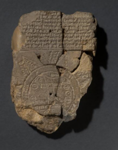
The earliest maps so far discovered are found on Babylonian clay tablets, and date back more than three millennia to about 2,300 B.C.
As you can see, this map looks very different from the elaborate paper maps most people are familiar with. For instance, ancient maps typically depicted small, local areas, were pictorial in nature, were not consistently oriented, were far less detailed than reality, and may almost be considered to be works of art more than reference documents.
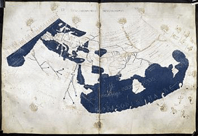
Cartography started to emerge into a form more recognizable to what we know today with the ancient Greeks. We can credit ancient Greek philosophers such as Ptolemy, Herodotus, Anaximander, and Eratosthenes for shaping cartography into the useful science it is today. While their understanding of the geography of the world was limited, their early renditions of the world as they understood it spurred future cartographers, such as the ancient Romans. Ptolemy’s original maps have never been found, but his descriptions of longitude and latitude influenced later cartographers and were enough to help cartographers recreate the Ptolemy map in 1300 AD.
 Medieval Maps
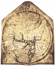
As human knowledge and understanding of the world expanded, so too did the accuracy of maps. One of the most important geographical texts from this time was the Tabula Rogeriana (circa 1154) crafted by Al Idrisi, an Arab scholar, for King Roger II of Sicily. Drawing from his own travels and conversations with explorers, Al Idrisi’s map was the most detailed geographical representation of the world to date and described the world as spherical, rather than flat. In the 1300s, an unknown cartographer created what is the largest and also one of the most detailed, albeit inaccurate, medieval map still in existence. Although the map is circular and not truly representative, by placing Jerusalem in the center and Europe and Africa mislabeled, it reflects medieval values and beliefs.
By 1450, a much more accurate representation of the Earth emerged with the monk Frau Mauro’s map depicting the entire known world at the time: Europe, Asia, and Africa oriented correctly. This map is regarded as one of the finest pieces of medieval cartography in existence.
 Renaissance Maps
It is not surprising that maps grew to be more expansive and detailed in the Renaissance: an age of art, exploration, and innovation. With the invention of the printing press, more advanced measurement tools, and the exploration and colonization of the New World maps evolved. Cartographers started to experiment with new features including navigation charts, 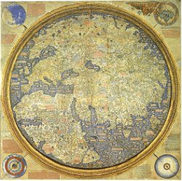 compass lines and other navigational aids, and globes. Juan de la Cosa, who sailed with Columbus, created what is believed to be the first map to show the Americas. Sebastian Munster’s Geographia, published in 1540, became a global standard for future maps of the world.
Although the first comprehensive world map was attributed to the cartographer Martin Waldseemuller in 1507, the single most important geographic contribution of this period was the Mercator Map. Gerardus Mercator of Flanders was the first cartographer to attempt to make the round world look accurate on a flat surface, and his representation, designed specifically to aid navigation since every straight line is a true compass bearing.
To the dismay of many geographers, however, the Mercator map is still used today. The reason for the dismay is that Mercator’s land masses dramatically distort in size as the closer they are to the poles. It’s the Mercator map, found in more grade school classrooms than any other, upon which most people’s mental image of Earth is based. Greenland, for example, looks enormous on the Mercator map, but in reality, it is smaller than Algeria. (Check it out – if you have the chance, compare a Mercator map to a globe.)
Modern Maps
Because of the use of satellite technology, modern maps are now more precise than was ever imagined possible in the past. Satellite imaging has a history of its own. The ability to punch your destination into your smartphone in a matter of seconds and be fairly confident that your GPS won’t let you down is relatively new in the history of satellite data. GPS, which began as a military tool, only became available to the public in the 1980’s, and the government first allowed truly accurate GPS to be used by the public in the year 2000.
I’ve only grazed the surface of the rich history of maps and mapping, but hopefully, you have seen from these two essays that there is much more to maps than meet the eye. The next time you depend upon a destination you’ve entered into Google Maps, remember to be grateful for the age in which you live.